MTB SlideShow
MTB Movie
Gps Mtb Tracks
Mtb Maintenance-Preparation
Artimino
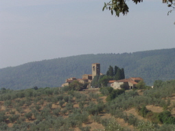
Mtb Tracks Florence to Artimino is Country on signa HillsMore.....
Morello Mount
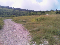
Mtb Tracks between Florence and e Morello Mount Legri Volmiano and MattaianoMore.....
Roveta Mount
Mtb Tracks Florence to Scandicci and Rinaldi go up to San Martino alla PalmaMore.....
Renai Park
From Florence go to Rigth Side to Arno river and go to Renai Park Signa CountryMore.....
President SlideShow

Slide Show on the Life the Italian Bigger President than Last 100 YearsSee.....
Pictures on Your President

Page with picture series on Sultanat of Italian PresidentSee.....
Jokes
Jokes on Berlusconi, Pope, Putin, Musulman People, On the Tv Rai and Madiaset, on the Qeen, on Iraq etc.More.....
Elettromagnetoterapy
Travels Around the World
Amsterdam - Lisbon
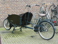
Amsterdam is a city of 750,000 inhabitants, where the Electric Trams run every max 10 'and are the Bicycle Master. At the train station parking for bikes full, makes it clear how many bikes circulating to the CityMore...
Populous city (nearly 4 million inhabitants with the hinterland), alive and vibrant in the succession of predominantly eighteenth and rationalist architecture, but also medieval, Manueline and Baroque, and, after the 1998 Expo, ultramodern, Lisbon is a city composite,More...
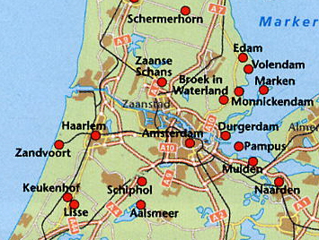
AMSTERDAM - DELFT - DEN HAAG - HAARLEM - MARKEN - SCHEVENINGEN - VOLENDAM - ZAANSE SCHANS - OTHERS

|
Groot
Mokum ',
this is the name that the
Jewish merchants, in the times
of the painter Rembrandt van
Rijn, gave
to the city.
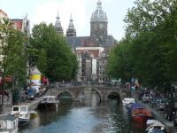
Amsterdam is a City of da 750.000 Peoples, Electric Trams run every where up to 10 'and are the Bicycle Master.Under the Parking Station which makes it clear how many bikes are moving to the city and a characteristic Bike Walk for Families or for shopping.
The
Main Square is Dam Square
and near about
300m the
Red Light District where
truly characteristic Day and
Evening perform behind
the display cases
strictly with Red Light
On, Black and
White Girls in
Underwear seductive. |
-
Currently Delft is known for its typical blue pottery, as the place where he worked as Vermeer and one of the oldest cities in the Netherlands (in no other place in the Netherlands there are so many channels in proportion).
Actually in the distant past, Delft was the scene of bloody events, the city of Baccalari in the 14th century had to surrender to the Count of Ami Aibrecht of Bavaria, in 1536 a fire destroyed much of the city and in 1572, shortly after the fall of Den Briel, follow the occupation of the Beggars.
I must say it is one of the loveliest and Dutch Cities where you can feel the real Holland.
Located about 30 km south of Den Haag and 30 km from Rotterdam
|
Den
Haag is the
city that we Italians
call the
Hague. |
|
Located about
30 km west of
Amsterdam is a typical
Dutch town,
Channels and Churches |
|
When the
monks left the island in the
14th century, dams
were abandoned to their fate
and the activities permitted
by the drainage of land as
agriculture and livestock farming
gave way to fishing. |
|
The original
appearance of the country,
with the maze of alleys
between the houses built
on stilts and
fishermen's harbor, close by on the
IJsselmeer, is well
preserved. |
|
Town on
the North Sea about 20
km north of
Den Haag (The
Hague) |
|
Located
about 50 km west of
Amsterdam is a typical
Dutch town,
full of mills still
used for the purpose
Operated Tourist |
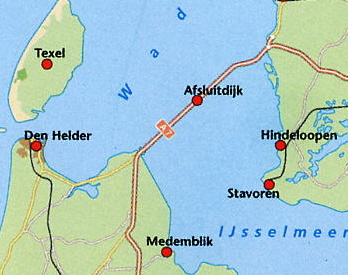


- AFSLUITDIJK
-
On May 28, 1932 in the presence of Queen Wilhelmina was closed the last
opening in the dam that would separate him from Zulderzee Wadden Sea /
North Sea.
The sheet of water inside the dam Afsluitdijk took the new name of the lake Usselmeer.
The province North-Holland had a direct motorway link with Pnsia.
The dikes around the lake, often little resistance, since they are no longer a source of risk in the event of heavy storms, such as that of 1916.
The water became salty, a bit 'at a time, sweet.
The operation of water runoff from the area around the IJsselmeer improved significantly for the new possibility of controlling the water level.
The creator of the work of the Zuiderzee was Comelis Leiy the engineer, who in 1891 succeeded in producing a viable project.
Leiy died in 1929, so I was able to witness the completion of his work.
The idea of closing the Zuiderzee, however, was not entirely new, in fact, already in 1667 Hendrik Stevin, son of Simon, had thought about the possibility of closing the arms of the sea between the Frisian Islands and the mainland. The project did not arouse much interest and it was impossible with the technology era.
From then to now in this area, the government was required the construction of eight polders (drained land).
Prior to the closure of the dam, offshore, was made the polder Wieringermeer peròaspettare It had until 1943, because the soil was ready to be cultivated.
In 1945 it flooded again by the invading Germans. In the meantime, has become a part dell'IJsselmeer Noordoost polder (48,000 h) and also
Flevoland (97,000 h) was snatched from the waves. The desire to realize the polder to the south of the dam Markermeer LeIystad-Enkhiuzen, collides (with un'oggi
strong criticism from, among others by environmental organizations (area where they feed on aquatic birds) and many practitioners of water sports. - HOEK VAN HOLLAND
- At the mouth
of the Nieuwe Waterweg
is Hoek van
Holland. (About 50
km north-west of Rotterdam)
This town has a harbor ferry line service that connects to Harwich (England) and forms an important link in the chain of exports of fruit and vegetables from the nearby area of Westland.
Originally part of the Hook of the village belonged to The Hague, but since 1914 has been combined in Rotterdam.
Now is therefore part of the region 'Rijnmond'.
The channel Rotterdam / Europoort was excavated between 1866 and 1872.
Belongs to the most outstanding examples of technology achieved in the control of the waters that allows you to close the Nieuwe Waterweg during storms and high water.
In May 1996, Queen Beatrix officially gave the boot to 'entry into operation of this piece of Deltawerken-' (Delta Works).
This dam protects more than a Million People from the North Sea Furies.
Hook of Holland, with its navigation facilities and beaches, is the favorite resort Rotterdammers
|
|
|
|
| MTB TRACKS | MTB SLIDESHOWS | SLIDESHOW TRAVELS | SLIDESHOWS TRAVELS | TRAVELS | TRAVELS | TRAVELS | TRAVELS | PROJECTS |
| Artimino Mount | Florence-Artimino Signa | Brasil-Recife | Portugal | Amsterdam | Egypte | Mykonos | United States | Merry Christmas Led |
| Morello Mount | Florence-Morello Mount | Crete | Praha | Austria | Formentera | New York | Switzerland | Crepuscolar Sensor |
| Roveta Mount | Florence-Roveta Mount | Cube | Rodhes | Balearic | France | Niagara Falls | Tunisie North | Water Sensor |
| Renai Park | Florence-Renai Park | Germany | Sicily | Berlin | Ibiza | Paris | Tunisie South | |
| Vaiano Bike Track | Florence-Vaiano | Ibiza-Formentera | Swizerland | Brasil | Italy | Paros | Twc | |
|
MTB GPS TRACKS |
MTB |
Holland-Amsterdam | Tunisie | Chambord | Lisboa | Portugal | Unghery | |
| Gps Tracks | Mtb Maintenance | Mykonos |
BERLUSCONI |
Corsica | London | Rep.Ceca |
PROJECT |
|
| Google Earth Tracks | Mtb Physical Training | Paris | Images | Crete | Maroco | Sardinia | Equalizator | |
| Excel Tracks | Anearobica Threshold | Paros | Slideshows | Cube | Mexico | Sicily | Magnetoterapy |
